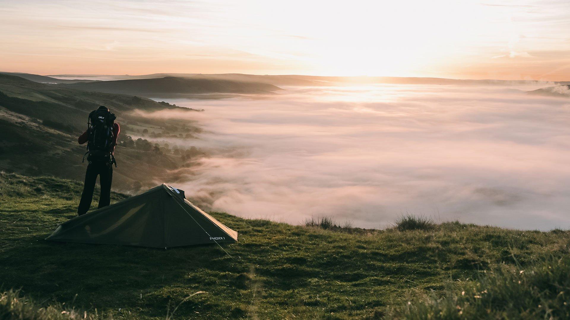
Stunning Summer Hikes to Enjoy this Season
The long days of summer offer the perfect conditions to lace up your boots and head for the hills. We’ve reached out to some avid adventurers throughout the UK and picked their brains on their favourite local hikes to do in summer. From stunning coastal walks to ticking off trig points, this article is packed with inspiration for your next trail-based jaunt.

Northumberland
A stunning spot for photographers to go wild, where the historic Norman Castle stands proud on top of a Basalt Crag, overlooking the expansive sands and the North Sea.
Seahouses to Bamburgh: Recommended by Rebecca Everett
Route Overview: The pristine expanse of the Northumberland Coastline is home of the most immaculate and quiet coastal scenes in the country. It’s a haven for surfers and watersport-ers alike. Set before soft sand dunes and studded with iconic landmarks, it’s a postcard at every turn. There are also some amazing places to eat! It’s hard to recommend just one route, from the picturesque village of Alnmouth where you can explore St Oswald’s Way and the Northumberland Coast Path, right up to the secluded shores of Ross Sands, the historical Holy Island of Lindisfarne and the heavenly town of Berwick-Upon-Tweed - some must-visit places, especially in the summer!
A definite recommendation for a good summer hike is Bamburgh, where you could take many different walking routes, such as the 9.7-km Seahouses to Bamburgh Route (linked below). A stunning spot for photographers to go wild, where the historic Norman Castle stands proud on top of a Basalt Crag, overlooking the expansive sands and the North Sea. It’s an out-and-back route, and you can do it in whichever direction you prefer. If you’re setting off in the morning I’d recommend doing it in reverse and refuelling with some fish and chips when you get to Seahouses. Check the tide times before you go. You can always come back on the adjacent road if the tide comes in.

Lake District
You are rewarded with views over Grasmere, Elterwater and the full northern expanse of Windermere.
Loughrigg Loop: Recommended by Jack Holman from Blacks Ambleside
Route Overview: This walk is one I have shared with friends and family on multiple occasions. It’s undoubtedly one of the best walks to do in the Lake District in summer. You start around Skelwith Bridge, parking permitting (more just up the road on Ellers Brow), then wind up alongside Loughrigg Tarn, an excellent spot for a summer swim. Then comes the challenge, off the flat path and traversing a field before finding the base of a stream that heads off up through leafy bracken all the way to the summit of Loughrigg.
Two-thirds of the way up the climb you leave the mix of steps and rock to ascend a grass slope that brings you just under the summit col. Loughrigg sits on the very end of the ridge that runs up to Sergeant Man, and you are rewarded with views not just across there, but over Grasmere, Elterwater and the full northern expanse of Windermere. On a good day of course.
From there, you descend towards Ambleside, making sure to avoid the main crag down-climb, and then cut right to come underneath the flanks of Loughrigg and back towards Skelwith Bridge. Here you end your walk, safe in the knowledge that a strong coffee and hearty slice of cake await at the cafe. Two to two and a half hours is a realistic time frame to achieve this little Wainwright loop.

North York Moors
The great thing about this walk is that there are several points along the way to grab a breather, take in the views and listen to the chirps from the local Grouse, who love to spring up out of nowhere!
Clay Bank To Carlton Bank: Recommended by Mark Thompson
Route Overview: Dropped off at Clay Bank car park, throw on my backpack and make off up the winding paths, towards the beautiful white, rocky marvel that is Hasty Bank! The views from the top looking over at Roseberry Topping in the distance or to the nearby Urra Moor always provide the perfect moment to exhale and breathe away all my troubles, in an instant!
From there I make my way to the iconic Wainstones and sit among the amazing rock formations to take on some water, before once again making off along the beautiful, winding stone paths. The great thing about this walk is that there are several points along the way to grab a breather, take in the views and listen to the chirps from the local Grouse, who love to spring up out of nowhere!
However, the deciding factor in making this my favourite summer walk is the lure of Lord Stones Country Park! Knowing you can stop off to enjoy a cooked meal and a beer, before making the final push up to Carlton Bank to take in an amazing sunset and round off a great day.
The route is around 4 miles, with lots of ups and downs. I would rate this quite a tough walk for the older generation, given the ups and downs on stone paths. But any seasoned walker or adult with a good level of fitness will manage just fine!

Yorkshire Dales
Once at the summit, the views are amazing, overlooking the other Yorkshire Peaks Ingleborough and Whernside. We decided to sit and take in the views at the top.
Pen-Y-Ghent: Recommended by Bethany Leedham from Blacks Head Office
Route Overview: The Yorkshire Dales has many amazing walks with beautiful scenery, but one of my favourites is Pen-Y-Ghent, which is one of the Yorkshire Three Peaks. It’s a Yorkshire classic! This great circular route starts in Horton-in-Ribblesdale and is around 6.5 miles. Being the lowest of the Yorkshire Three Peaks at 694m, it’s a popular choice for hikers of all abilities. This route is also really accessible by public transport if you don’t drive as well. I completed this walk at the start of Summer, and the weather made it a great day out. I’d like to complete the other two Yorkshire Three Peaks this summer as well whilst the weather is good.
After reading reviews and researching, we decided to do the route clockwise for a more gradual climb to the summit. The route was well signposted with good paths all the way up. Once at the summit, the views are amazing, overlooking the other Yorkshire Peaks Ingleborough and Whernside. We decided to sit and take in the views at the top. We then headed down the steep southern side – it was a slight scramble down Brackenbottom Scar but if you’re prepared, it’s nothing too major. The route down after the scrambling is a leisurely descent back down the Ribblesdale Valley towards the River Ribble.
I’d definitely recommend this route if you’re looking to tick off one of the highest peaks in Yorkshire.

Peak District
Take a small detour to the edge of the dramatic cliff tops that look down on the famous Winnats Pass.
Back way to Castleton: Recommended by Ethan Ball from Blacks Head Office
Route Overview: My favourite Peak District Summer hike is a 6-mile route that has everything from wide open fields to rocky scrambles, Stony cliff tops and cave-littered dales. It’s got a segment of steep elevation to its highest point at the top of Mam Tor (517m). This hike has something for everyone, is full of points of interest and can be easily tweaked to be made easier or more difficult.
The hike begins at a brook that runs under large oak trees near an old cemetery in Edale. From there, you cross flat fields passing through numerous stone stiles and streams until you reach the base of the north side of Mam Tor. This is the scrambliest part of the hike, as this steep ascent is going to take you off the beaten track and up small gullies, which in winter would be flowing with mud and water. In Summer these are dry and rocky enough to safely scramble up, being sure to be aware of numerous loose rocks. I would recommend footwear with good traction, such as trail running shoes or flexible boots with deep lugs.
Once you get to the top, you’ll find yourself standing on the Great Ridge of Mam Tor. Heading south-west up the ridge you’ll see the trig point coming into view and on a clear summer’s day you can see the green landscape rolling into the distance for miles. Looking south you can see down into Hope Valley and the town of Castleton.
Carrying on past the trig point and going down large flagstone steps past the remains of an iron age tomb, you’ll gently slope down the south side of Mam Tor to meet a small road called Sparrowpit. Crossing this you will see a wooden gate that marks the start of a path that allows you to take a small detour to the edge of the dramatic cliff tops that look down on the famous Winnats Pass. In Summer this is a great place to eat while taking in the views before heading southeast to meet the path again.
As you follow the path around to face north, you’ll see grassy banks rising on either side and the ground will become stonier until you’re walking on loose rocks that lead down between two tall stones. This is the entrance to Cave Dale, known locally as the Secret Valley. It’s long, wide, and very quiet with steep rocky slopes on either side with small caves and the perfect place to practice your bouldering skills. If you look up halfway through the valley, you can see the ruined keep of Peveril Castle standing on a rocky edge. At the north end, the ground becomes stonier again and the path turns into an alleyway with fern-covered rock that stands at about 20ft high on either side, leading you suddenly into the cottage-lined streets of Castleton and its many pubs.

Pembrokeshire Coast
This section of the Pembrokeshire Coastal Path is a breathtaking stretch of coastline that encapsulates the natural beauty and rugged charm of Wales.
Pembrokeshire Coast Path (St Davids Head to Aber Pwll): Recommended by Chrissy Raider
Route Overview: Each year my friend Becky and I hike a national trail, this year we chose the Pembrokeshire Coastal Path and what a trip it was! 200 miles and 10 days of Coastal bliss. The most memorable being the section from St Davids Head to Aber Pwll.
This section of the Pembrokeshire Coastal Path is a breathtaking stretch of coastline that encapsulates the natural beauty and rugged charm of Wales. You are blown away by panoramic views of the Celtic Sea, with its azure waters stretching as far as the eye can see. The rugged cliffs, carved by centuries of wind and waves, are a sight for sore eyes providing a dramatic backdrop to the pristine beaches below. Meander along the cliff edges, to observe nesting seabirds, including puffins, guillemots, and razorbills. The wildflowers along the whole coastal path in May were just beautiful.
As you approach Aber Pwll, the landscape transitions into a tranquil estuary, where salt marshes and mudflats provide a haven for even more species of birds. The section from St Davids Head to Aber Pwll is a true gem along the Pembrokeshire Coastal Path. Whether you seek adventure, solitude, or simply an opportunity to connect with nature, this segment will leave an indelible mark on your memory.

South Downs
Climb over Beacon Hill to reach the trig points and enjoy the stunning view over the rolling hills of the South Downs. This is my favourite spot!
Harting Downds to Amberly: Recommended by Aaron Jewell
Route Overview: The South Downs Way is my favourite place to spend my time and the hike of choice is always Harting Downs to the village of Amberly.
Starting at the remote car park of Harting Downs, a 10-minute drive from nearby Petersfield, the trail nearly entirely follows the South Downs way for 18 miles and approx 2000ft of total ascent enjoying stunning views over the South Downs from start to finish.
Approximately one mile from the start you will briefly leave the SDW and climb over Beacon Hill to reach the trig points and enjoy the stunning view over the rolling hills of the South Downs. This is my favourite spot! As you descend the other side back down the well-signposted trail of the SDW, you enjoy constant sweeping views of the countryside. Starting early is fantastic, walking head-on towards a stunning sunrise. At the end of the hike, as you descend to the river Arun running through Amberly, you can find a café or pub to refuel and a train station to retreat home. There is also an option to extend your walk by following the river to the beautiful town of Arundel and its many coffee shops.