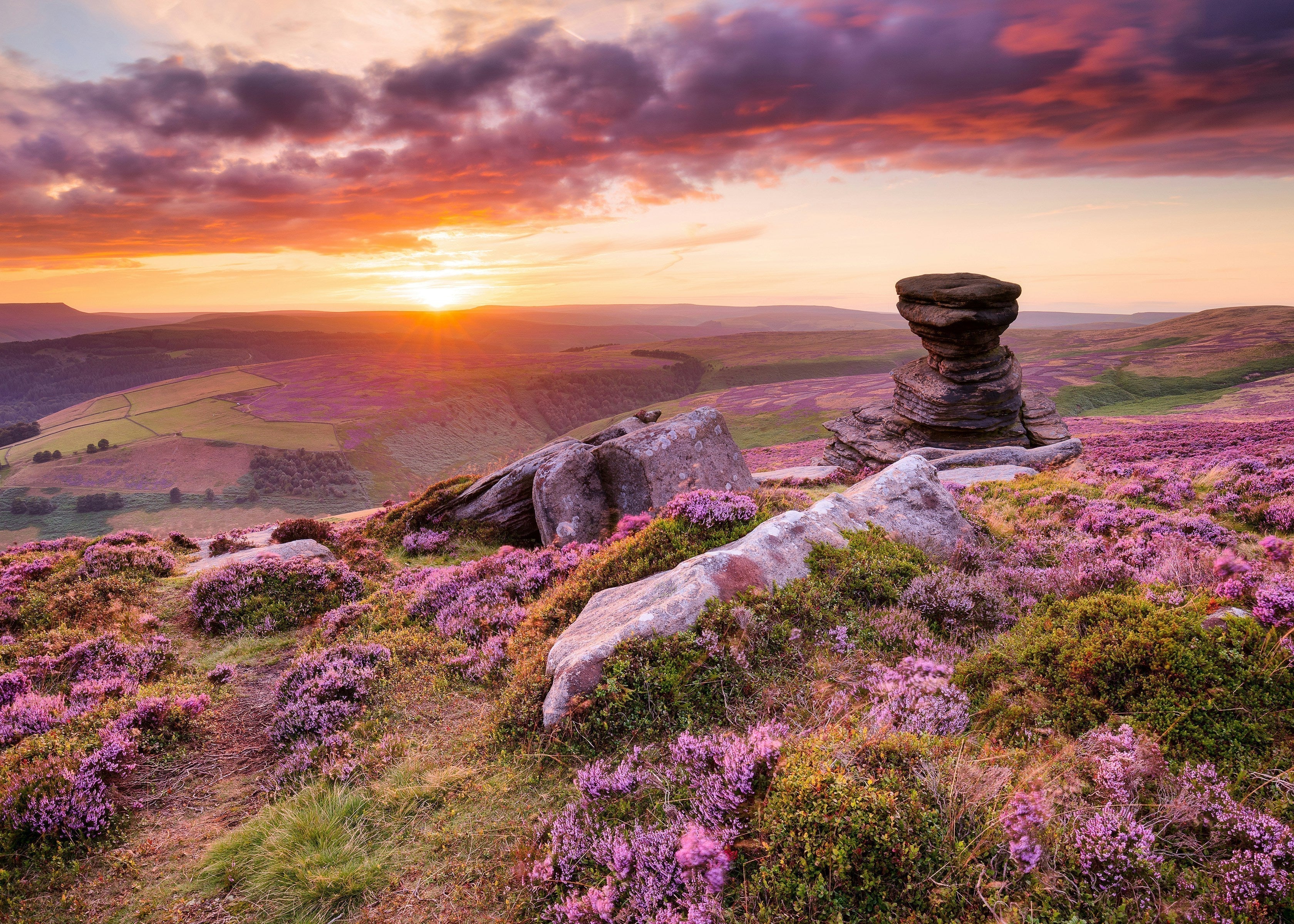
Hiking Hotspots: The UK's Best Hiking Locations

With its varied landscapes, rich history, and extensive network of trails, the UK is a haven for hiking enthusiasts. Whether you're lacing up your walking boots for a leisurely walk or a challenging trek, there’s something to suit every hiker's taste.
But which parts of the country are the best hiking hotspots? We’ve compared the UK’s biggest towns and cities based on several factors, including the most trails, lakes and water views, the opportunity to see plants and wildlife, the weather, and more.
Jump to:
England’s best hiking hotspots
Scotland’s best hiking hotspots
Wales’ best hiking hotspots
Northern Ireland’s best hiking hotspots
The most popular hiking hotspots on social media
The areas with the most wildlife hikes
Innovative gear for different weather conditions
Innovative gear for different types of terrain
General tips for enhancing your hiking experience
Methodology
England’s best hiking hotspots
| Rank | City/Town | County | Trails Per 10 km2 | Trails Rated ‘moderate’ | Trails Rated ‘hard’ | Dog Friendly Trails | Trails with water views | Trails with wildflowers | Trails with wildlife | Trails with eateries | Trails with 1,000m+ elevation gain | 20 km+ trails | Average trail rating /5 | Total number of sunrise & sunset social media posts | Average temperature (˚C) | Average annual precipitation | Outdoor activities per 10 km2 | Restaurants that are wheelchair-accessible | Campsites per 10 km2 | Hiking hotspot score /10 |
|---|---|---|---|---|---|---|---|---|---|---|---|---|---|---|---|---|---|---|---|---|
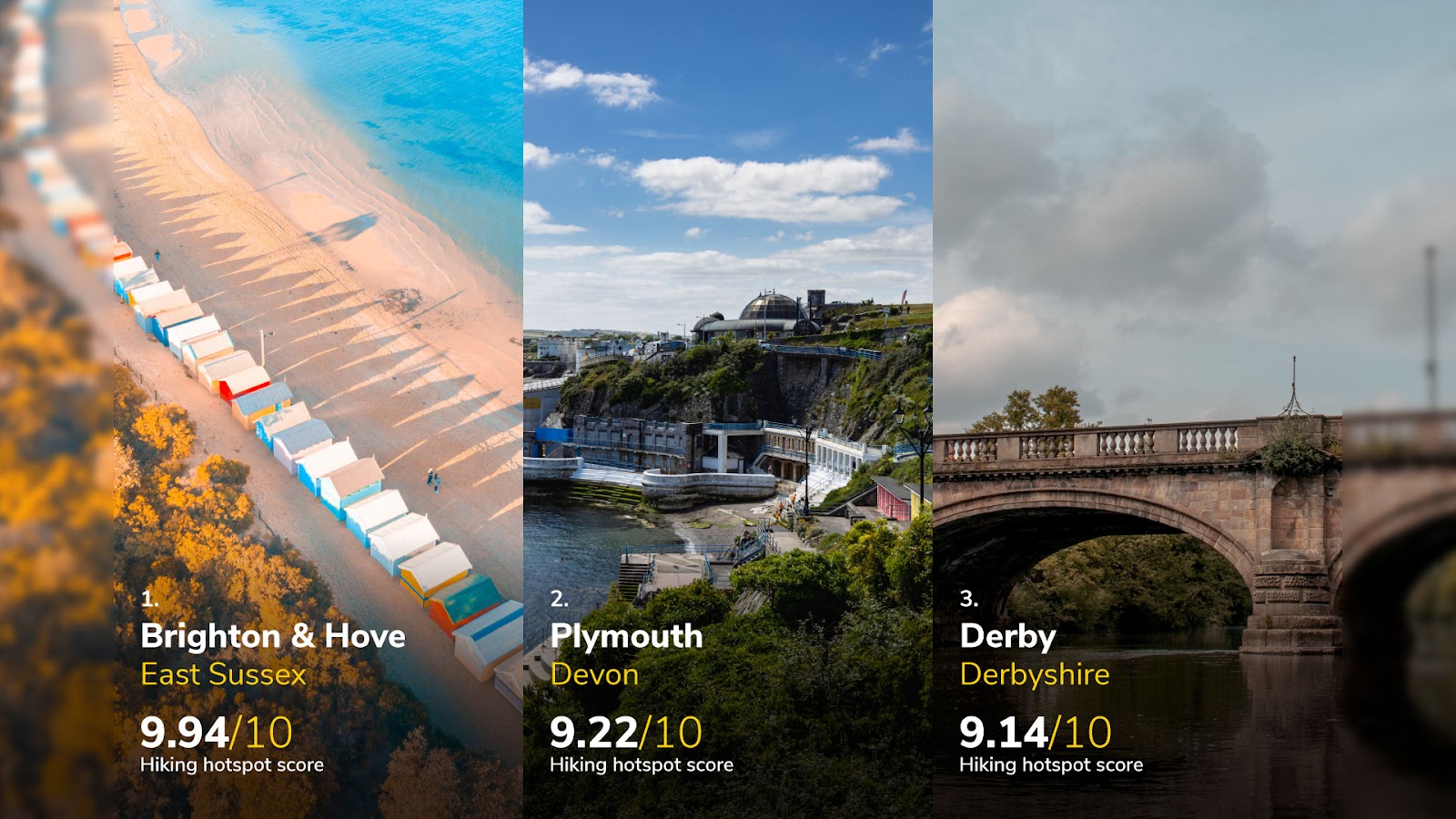
| 1 | Brighton & Hove | East Sussex | 13 | 68% | 21% | 23% | 9% | 58% | 55% | 26% | 2% | 30% | 4.5 | 12,609 | 10.9 | 912 | 4.8 | 25% | 13.1 | 9.94 |
| 2 | Plymouth | Devon | 13 | 51% | 11% | 26% | 55% | 53% | 64% | 9% | 8% | 15% | 4.5 | 1,167 | 10.9 | 1,028 | 0.7 | 33% | 5.5 | 9.92 |
| 3 | Derby | Derbyshire | 12 | 51% | 20% | 28% | 69% | 44% | 48% | 28% | 4% | 15% | 4.0 | 253 | 9.8 | 763 | 3.1 | 33% | 4.0 | 9.14 |
| 4 | Oxford | Oxfordshire | 18 | 47% | 8% | 15% | 53% | 74% | 56% | 26% | 2% | 6% | 4.0 | 851 | 10.3 | 708 | 2.6 | 36% | 4.9 | 9.11 |
| 5 | York | North Yorkshire | 29 | 43% | 9% | 20% | 55% | 44.% | 49% | 24% | 6% | 12% | 4.0 | 551 | 9.5 | 755 | 4.4 | 37% | 15.7 | 9.10 |
| 6 | Ipswich | Suffolk | 8 | 39% | 9% | 33% | 48% | 45% | 52% | 21% | 3% | 12% | 4.0 | 361 | 10.7 | 724 | 6.1 | 33% | 6.6 | 8.90 |
| 7 | London | London | 6 | 47% | 7% | 42% | 62% | 34% | 32% | 20% | 4% | 12% | 4.0 | 127,466 | 10.8 | 690 | 1.2 | 41% | 2.6 | 8.84 |
| 8 | Swindon | Wiltshire | 12 | 46% | 20% | 30% | 38% | 48% | 58% | 16% | 6% | 16% | 4.0 | 120 | 10.2 | 766 | 3.5 | 35% | 3.0 | 8.81 |
| 8 | Bristol | Bristol | 23 | 46% | 9% | 36% | 61% | 53% | 50% | 22% | 3% | 9% | 4.0 | 3,405 | 10.4 | 824 | 1.4 | 24% | 3.8 | 8.81 |
| 10 | Chelmsford | Essex | 15 | 59% | 5% | 18% | 62% | 59% | 54% | 23% | 0% | 13% | 4.0 | 25 | 10.6 | 649 | 4.7 | 36% | 2.0 | 8.70 |
1. Brighton & Hove, East Sussex - 9.94 out of 10
Brighton & Hove secures the top position with an impressive hiking hotspot score of 9.94 out of 10. Around one in three (30%) of the city’s trails are over 20 km, with diverse trail difficulties. With around two-thirds of its trails rated as 'moderate' and a fifth as 'hard', it caters to both casual hikers and more experienced adventurers. The area is particularly notable for its trails with wildflowers (58%) and wildlife (55%), adding some vibrant natural elements to the hiking experience. For example, Devil’s Dyke is situated in the South Downs just north of Brighton and is a legendary spot for both its panoramic views and its rich biodiversity. The area is lovely in the spring when the wildflowers are in bloom. Additionally, just over a quarter of the trails are near places to eat, making it ideal to grab a bite to eat on the way. The city is also beautiful for a sunrise or sunset walk, with 12,609 posts on social media.
2. Plymouth, Devon - 9.22 out of 10
Plymouth ranks second with a score of 9.22. It is home to nine trails per 10 km², 8% of which have an elevation of over 1,000 m, ensuring various challenging hiking experiences. Plymouth also excels in trails with wildflowers (53%) and wildlife (64%), offering immersive natural encounters. The city also enjoys relatively warm weather, with an average annual temperature of 10.9˚C, and has seen 1,167 social media posts about its sunrises and sunsets. One of the most popular trails in Plymouth is the South West Coast Path. This renowned long-distance walking route starts in Minehead, Somerset, and runs along the coastline to Poole in Dorset, but the sections near Plymouth offer some spectacular coastal scenery.
3. Derby - 9.14 out of 10
Derby takes the third spot with a hiking hotspot score of 9.14. The city offers 12 trails per 10 km², with a good balance of trail difficulties (51% moderate, 20% hard). It is renowned for its high percentage of trails with water views (69%), the highest among the top three, providing excellent opportunities for waterside trekking. Additionally, Derby has plenty of trails with eateries (28%) and long-distance options (4%), such as the Pennine Way, which is considered one of the UK's most famous long-distance footpaths, stretching about 268 miles (431 km) north to Kirk Yetholm in the Scottish Borders.
Scotland’s best hiking hotspots
| Rank | City/Town | County | Trails Per 10 km2 | Trails Rated ‘moderate’ | Trails Rated ‘hard’ | Dog Friendly Trails | Trails with water views | Trails with wildflowers | Trails with wildlife | Trails with eateries | Trails with 1,000m+ elevation gain | 20 km+ trails | Average trail rating /5 | Total number of sunrise & sunset social media posts | Average temperature (˚C) | Average annual precipitation | Outdoor activities per 10 km2 | Restaurants that are wheelchair-accessible | Campsites per 10 km2 | Hiking hotspot score /10 |
|---|---|---|---|---|---|---|---|---|---|---|---|---|---|---|---|---|---|---|---|---|
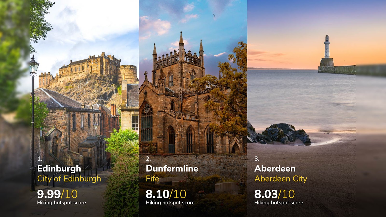
| 1 | Edinburgh | Edinburgh | 11 | 39% | 15% | 36% | 46% | 39% | 37% | 17% | 12% | 21% | 4.0 | 7,550 | 8.3 | 868 | 7.4 | 32% | 2.7 | 9.99 |
| 2 | Dunfermline | Fife | 12 | 25% | 0% | 38% | 42% | 54% | 58% | 13% | 0% | 0% | 4.5 | 12 | 8.4 | 932 | 1.9 | 40% | 1.9 | 8.10 |
| 3 | Aberdeen | Aberdeen | 12 | 25% | 4% | 34% | 23% | 44% | 58% | 0% | 4% | 6% | 4.0 | 950 | 8.8 | 868 | 4.5 | 34% | 0.3 | 8.03 |
| 4 | Paisley | Renfrewshire | 7 | 56% | 6% | 50% | 50% | 56% | 67% | 0% | 6% | 6% | 4.0 | 182 | 8.4 | 1,296 | 1.5 | 23% | 2.3 | 7.97 |
| 5 | Glasgow | Glasgow | 13 | 37% | 7% | 34% | 48% | 41% | 6% | 2% | 6% | 7% | 4.0 | 5,168 | 8.1 | 1,228 | 1.8 | 25% | 0.5 | 7.77 |
1. Edinburgh, City of Edinburgh - 9.99 out of 10
Edinburgh leads as Scotland’s top hiking hotspot with a score of 9.99. The city offers 11 trails per 10 km², blending moderate (39%) and hard (15%) trails suitable for various hikers. It’s also notable for the length and elevation of its walks, with around a fifth (21%) being over 20 km and 12% being over 1,000 m. Among Edinburgh’s trails, Arthur’s Seat offers a moderately challenging hike right in the city's heart with panoramic views from the top. The Water of Leith Walkway is another gem that provides a tranquil escape along the river, stretching from the city centre into the serene outskirts. This trail is particularly beautiful in spring when wildflowers bloom. For those seeking more of a challenge, the Pentland Hills just outside the city have over 100 km of trails, with some reaching over 500m elevation, providing moderate and strenuous hiking options. With 2.7 campsites per 10 km², there are plenty of accommodation options near the city, too, and there’s more than enough to do after your hike, too, with 7.4 outdoor activities per km².
2. Dunfermline, Fife - 8.10 out of 10
Dunfermline ranks second with a score of 8.10. The area offers 12 trails per 10 km², with an average trail rating of 5 out of 5. The Fife Coastal Path provides a long stretch of scenic views where hikers can enjoy the coastline, which often includes sightings of seals and a variety of seabirds. For a more wooded experience, the trails at Pittencrieff Park wind through lush greenery and historical structures, ideal for a family-friendly hike. Dunfermline is particularly notable for its dog-friendly trails (38%) and campsites per 10 km² (1.9). It also has many trails with eateries (13%), with 40% of its restaurants being wheelchair-accessible.
3. Aberdeen, Aberdeen City - 8.03 out of 10
Aberdeen is third with a score of 8.03. This city provides 12 trails per 10 km² with 4% having an elevation gain of over 1,000m. The Old Deeside Railway Line is popular among locals for its historical significance and gentle path, which is ideal for cyclists and casual walkers alike. For a touch of the rugged Scottish landscape, the Bennachie Range provides several trails leading to different peaks, with Mither Tap offering stunning views of Aberdeenshire from its summit. Among Scottish cities, Aberdeen also has some of the better weather among Scottish cities, with an average temperature of 8.8˚C and rainfall of 868mm. Outdoor activities are also noteworthy, with 4.5 per 10 km².
Wales’ best hiking hotspots
| Rank | City/Town | County | Trails Per 10 km2 | Trails Rated ‘moderate’ | Trails Rated ‘hard’ | Dog Friendly Trails | Trails with water views | Trails with wildflowers | Trails with wildlife | Trails with eateries | Trails with 1,000m+ elevation gain | 20 km+ trails | Average trail rating /5 | Total number of sunrise & sunset social media posts | Average temperature (˚C) | Average annual precipitation | Outdoor activities per 10 km2 | Restaurants that are wheelchair-accessible | Campsites per 10 km2 | Hiking hotspot score /10 |
|---|---|---|---|---|---|---|---|---|---|---|---|---|---|---|---|---|---|---|---|---|
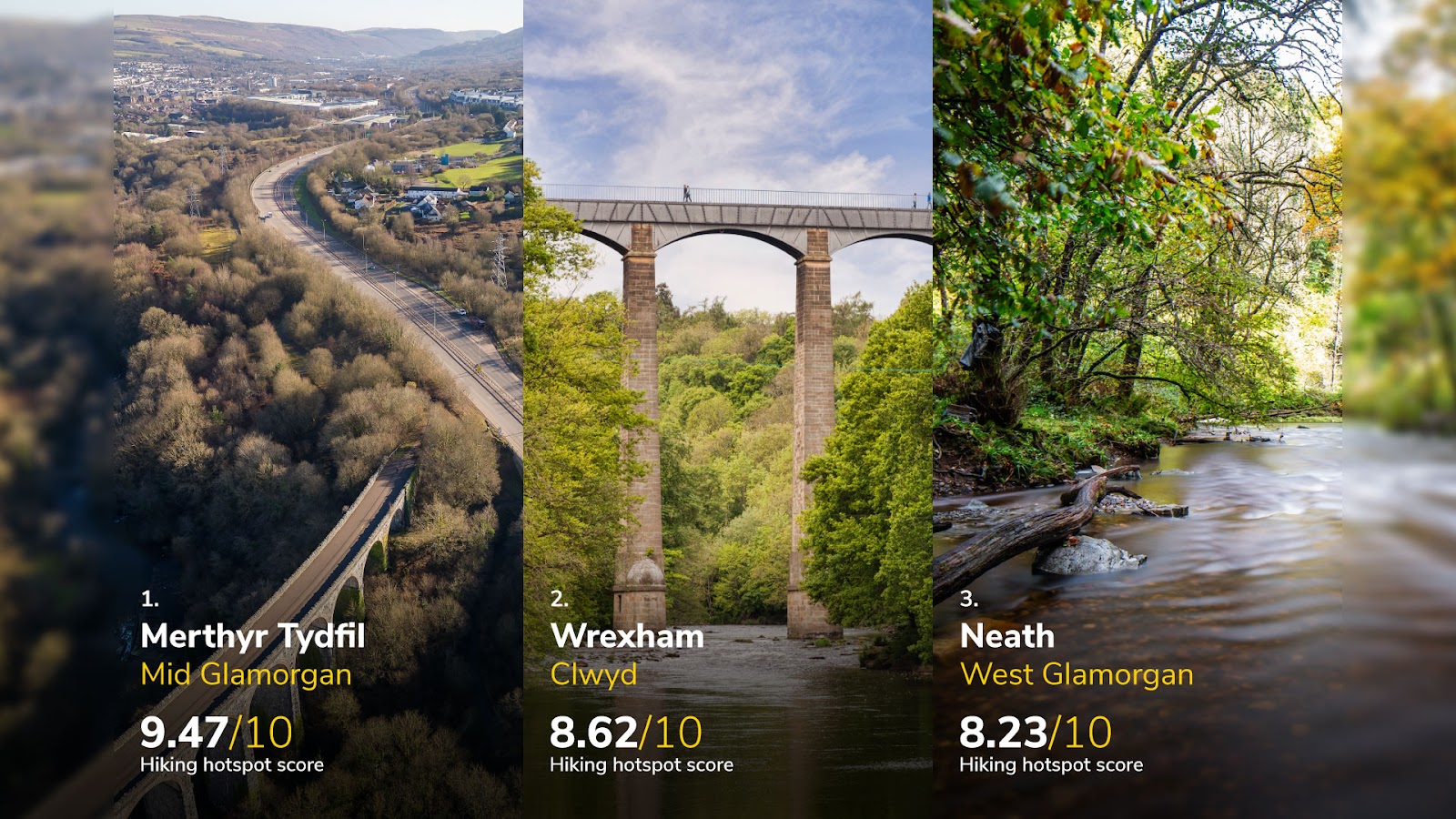
| 1 | Merthyr Tydfil | Mid Glamorgan | 24 | 33% | 41% | 30% | 74% | 48% | >59% | 4% | 11% | 26% | 4.5 | 8 | 9.0 | 1,227 | 3.6 | 32% | 16.2 | 9.47 |
| 2 | Wrexham | Clwyd | 25 | 47% | 6% | 22% | 50% | 25% | 25% | 9% | 3% | 9% | 4.5 | 9 | 9.3 | 831 | 4.8 | 46% | 18.3 | 8.62 |
| 3 | Neath | West Glamorgan | 29 | 53% | 15% | 15% | 74% | 35% | 35% | 3% | 3% | 18% | 4.5 | 3 | 9.7 | 1,418 | 3.4 | 36% | 6.7 | 8.23 |
| 4 | Newport | Gwent | 9 | 45% | 13% | 16% | 63% | 37% | 39% | 11% | 3% | 5% | 4.0 | 4,702 | 10.3 | 919 | 2.5 | 36% | 4.0 | 8.10 |
| 5 | Cwmbran | Gwent | 8 | 67% | 0% | 58% | 67% | 33% | 33% | 8% | 0% | 25% | 4.5 | 5 | 9.8 | 942 | 0.7 | 37% | 9.6 | 8.03 |
1. Merthyr Tydfil, Mid Glamorgan - 9.47 out of 10
Merthyr Tydfil stands out as the top hiking hotspot in Wales, with an impressive score of 9.47. This area boasts 24 trails per 10 km², catering to a diverse range of hikers, with 33% moderate and a substantial 41% rated as 'hard'. It is particularly renowned for its scenic water views, present on almost three-quarters (74%) of trails, such as the Pontsticill Reservoir, which offers a picturesque loop, ideal for both walking and cycling and is especially beautiful in the autumn. Wildlife observations are possible on 59% of the trails, and wildflowers on nearly half (48%) of the trails, adding to the aesthetic appeal of the hikes. Merthyr also has the most long and high hikes per person in Wales. Around a quarter are over 20 km, and 11% are over 1,000 m. They include the Brecon Beacons Way, which features rugged terrain and breathtaking views, particularly from Pen y Fan, the highest peak in southern Britain. The Taf Fechan Forest offers gentler paths in dense woodlands and alongside glistening streams.
2. Wrexham, Clwyd - 8.62 out of 10
With a score of 8.62, Wrexham offers 25 trails per 10 km², with 47% rated as moderate. The standout trail is the Clywedog Trail, a scenic path that follows the River Clywedog through lush woodland and past historical sites like the Minera Lead Mines. For those interested in a more varied landscape, the North Berwyn Way offers dramatic views of the Dee Valley and Berwyn Mountains. This area also boasts the Chirk Aqueduct and Tunnel Walk, which are great places to see historical sites alongside the canal-side scenery. It also features 18.3 campsites per 10 km², and 46% of its restaurants are wheelchair-accessible. The area enjoys a slightly warmer climate than the other Welsh cities, with an average temperature of 9.3°C and receives 831mm of precipitation annually.
3. Neath, West Glamorgan - 8.23 out of 10
Neath scores 8.23 and boasts 29 trails per 10 km², more than any of the other Welsh cities. It also has a good mix of hard (15%) and moderate (53%) trails and those with water views (74%), like the Neath Canal Path, which provides a peaceful waterside walk accessible to all levels of hikers and is ideal for bird-watching. For a more secluded and wild experience, the trails at Margam Country Park offer historic landmarks like Margam Castle and natural wonders, including the chance to see deer. The park’s varied terrain makes it suitable for both serious hikers and family outings. It also has large numbers of trails with wildflowers (35%) and those over 20km (18%).
Northern Ireland’s best hiking hotspots
| Rank | City/Town | County | Trails Per 10 km2 | Trails Rated ‘moderate’ | Trails Rated ‘hard’ | Dog Friendly Trails | Trails with water views | Trails with wildflowers | Trails with wildlife | Trails with eateries | Trails with 1,000m+ elevation gain | 20 km+ trails | Average trail rating /5 | Total number of sunrise & sunset social media posts | Average temperature (˚C) | Average annual precipitation | Outdoor activities per 10 km2 | Restaurants that are wheelchair-accessible | Campsites per 10 km2 | Hiking hotspot score /10 |
|---|---|---|---|---|---|---|---|---|---|---|---|---|---|---|---|---|---|---|---|---|
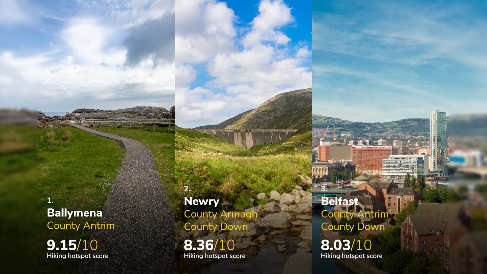
| 1 | Ballymena | County Antrim | 32 | 42% | 17% | 38% | 57% | 32% | 51% | 2% | 2% | 8% | 4.0 | 25 | 9.0 | 956 | 1.8 | 44% | 0.0 | 9.15 |
| 2 | Newry | County Armagh County Down | 61 | 36% | 48% | 12% | 43% | 23% | 36% | 0% | 6% | 9% | 4.5 | 7 | 9.2 | 918 | 2.8 | 40% | 0.0 | 8.36 |
| 3 | Belfast | County Antrim County Down | 5 | 43% | 2% | 31% | 65% | 35% | 29% | 0% | 0% | 2% | 4.0 | 834 | 9.5 | 979 | 2.0 | 33% | 0.3 | 8.03 |
| 4 | Derry | County Londonderry | 2 | 71% | 0% | 29% | 100% | 71% | 71% | 0% | 0% | 0% | 4.5 | 84 | 9.2 | 1,102 | 5.0 | 32% | 0.6 | 7.77 |
| 5 | Lisburn | County Antrim County Down | 4 | 25% | 13% | 38% | 63% | 25% | 25% | 0% | 0% | 13% | 4.5 | 2 | 9.3 | 979 | 2.6 | 27% | 1.0 | 7.58 |
1. Ballymena, County Antrim - 9.15 out of 10
Ballymena tops the list as Northern Ireland's premier hiking hotspot with a score of 9.15. It boasts the second-highest number of trails per area in the top rankings, offering 32 trails per 10 km². These trails are varied, with 42% rated moderate and 17% as hard, catering to various hiking abilities. The Slemish mountain trail stands out as a must-visit for its historical significance and the challenge it offers. It's the legendary first-known Irish home of Saint Patrick, with a steep climb that rewards hikers with sweeping views of the Antrim countryside. For those looking for a less strenuous but equally rewarding experience, the Ballymena to Glenarm section of the Ulster Way offers lush landscapes, river scenes, and coastal views, making it ideal for moderate hikers and nature lovers. Almost two-fifths (38%) of the trails are dog-friendly, making it an excellent location for pet owners to explore the outdoors. Notably, it’s one of the only towns and cities where the walks are near places to eat. Speaking of restaurants, 40% of them in the town are wheelchair accessible too.
2. Newry, Counties Armagh & Down - 8.36 out of 10
Newry, with a score of 8.36, stands out with 61 trails per 10 km², the highest among Northern Irish cities. It has a rich selection of hard trails (48%), and 6% have an elevation gain of over 1,000m. Newry is surrounded by some of the most scenic landscapes in Northern Ireland, including the Ring of Gullion, a geological formation designated an Area of Outstanding Natural Beauty. The challenging Slieve Gullion mountain loop appeals to experienced hikers with its rugged terrain and panoramic views from the summit. For those interested in historical sites, the Newry Canal Way offers a gentler path along Ireland's first summit-level canal with opportunities to spot local wildlife. The area has a moderate climate, too, with just 918 mm of precipitation annually.
3. Belfast, Counties Antrim & Down - 8.03 out of 10
Belfast scores 8.03 and receives the most posts about its sunrises and sunsets, with 834. It is also known for its scenic routes, especially with water views in 65% of its trails and wildflowers in 35%. Belfast also has a high level of moderately tricky hikes, with 43%. The Lagan Towpath is particularly popular, featuring scenic river views and connecting Belfast to Lisburn. This trail is excellent for bird-watching and enjoying a peaceful water-side stroll. For a more substantial hike, the Divis and Black Mountain paths provide a more rural experience outside the city, with stunning views over Belfast Lough and beyond.
The most popular hiking hotspots on social media
| Rank | City/Town | County | Region | Posts on social media |
|---|---|---|---|---|
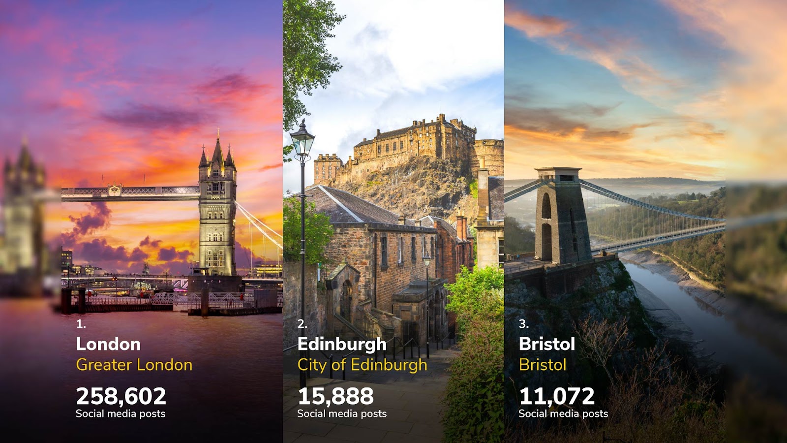
| 1 | London | London | London | 258,602 |
| 2 | Edinburgh | Edinburgh | Scotland | 15,888 |
| 3 | Bristol | Bristol | South West | 11,072 |
| 4 | Manchester | Greater Manchester | North West | 5,374 |
| 5 | Sheffield | South Yorkshire | Yorkshire & the Humber | 5,212 |
| 6 | Glasgow | Glasgow | Scotland | 4,248 |
| 7 | Oxford | Oxfordshire | South East | 3,567 |
| 8 | Cambridge | Cambridgeshire | East of England | 3,081 |
| 9 | Cardiff | South Glamorgan | Wales | 2,482 |
| 10 | Leeds | West Yorkshire | Yorkshire & the Humber | 2,377 |
For each area, we also took the number of posts on Instagram and TikTok for various terms, such as the city name followed by “hike” and “walk”. Here are the places that were the most posted about.
1. London - 258,602 posts
First, with more posts than all the other towns and cities combined, is London. London offers a unique hiking experience where urban life meets nature. Despite being a bustling metropolis, the city has plenty of green spaces and river paths that provide a peaceful retreat. Hiking here means walking through vast parks filled with ancient trees, open meadows, and occasional wildlife while within the city’s iconic skyline.
2. Edinburgh, Scotland - 15,888 posts
Edinburgh, with its dramatic landscape of hills and volcanic formations, is a city made for hikers. The city’s natural features are a big part of its charm, offering challenging hikes with rewarding views over the historic streets and out to the sea. Hiking in Edinburgh is as much about soaking in the city’s rugged beauty as exploring its deep historical roots.
3. Bristol, South West - 11,072 posts
Bristol combines urban exploration with the open space of the surrounding countryside. The city is known for its vibrant culture and stunning views, particularly where it meets the Avon Gorge's natural landscapes and the rolling hills nearby. Hiking in Bristol often involves crossing from lively urban areas into tranquil, green spaces, where you can see the contrast between the city’s industrial history and more peaceful, natural places.
The areas with the most wildlife hikes

| Rank | City/Town | County | Trails with wildlife |
|---|---|---|---|
| 1 | East Kilbride | South Lanarkshire | 100% |
| 2 | Coventry | West Midlands | 78.3% |
| 3 | Watford | Hertfordshire | 72.7% |
| 4 | Derry | County Londonderry | 71.4% |
| 5 | Slough | Berkshire | 66.7% |
| 5 | Cumbernauld | North Lanarkshire | 66.7% |
| 7 | Middlesbrough | North Yorkshire | 64.2% |
| 7 | Plymouth | Devon | 64.2% |
| 9 | Gateshead | Tyne & Wear | 62.5% |
| 9 | Sale | Greater Manchester | 62.5% |
| 9 | High Wycombe | Buckinghamshire | 62.5% |
| 9 | Hamilton | South Lanarkshire | 62.5% |
| 9 | Bournemouth | Dorset | 62.5% |
1. East Kilbride, South Lanarkshire - 100%
While there are only a small number of walks overall, each available trail in East Kilbride offers the opportunity to see wildlife. Situated in South Lanarkshire, Scotland, this town offers a rich array of natural landscapes, including woodlands, rivers, and open spaces that provide habitats for various wildlife species. These include the Calderglen Country Park and the Tor Trail, home to different bird species, mammals, and insects.
2. Coventry, West Midlands - 78.3%
Coventry ranks second, with 78.3% of its trails offering wildlife encounters. Despite its urban setting in the West Midlands, Coventry has made significant efforts to incorporate natural spaces within the city. Parks like Coombe Abbey Park and the War Memorial Park provide diverse habitats for wildlife, including deer, waterfowl, and various bird species.
3. Watford, Hertfordshire - 72.7%
Watford comes in third, with 72.7% of its trails featuring wildlife. Located in Hertfordshire, just north of London, Watford benefits from its proximity to several green spaces and natural reserves, such as Cassiobury Park and the Colne Valley. These areas host a wide range of species, from small mammals and amphibians to numerous bird species.
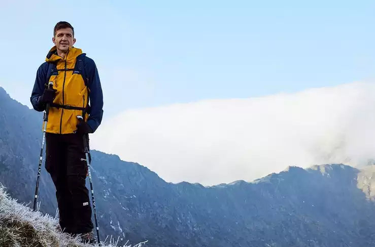
Calum Jones, author and outdoors enthusiast at Blacks, shares insights on the latest gear innovations to help you make the most out of every hiking adventure:
“Hiking is a rewarding activity, but the right equipment can significantly enhance your experience, especially when dealing with various weather conditions and terrains. Here’s how modern innovations in hiking gear can help you tackle different environments with confidence:
Innovative gear for different weather conditions
Sunny & hot weather
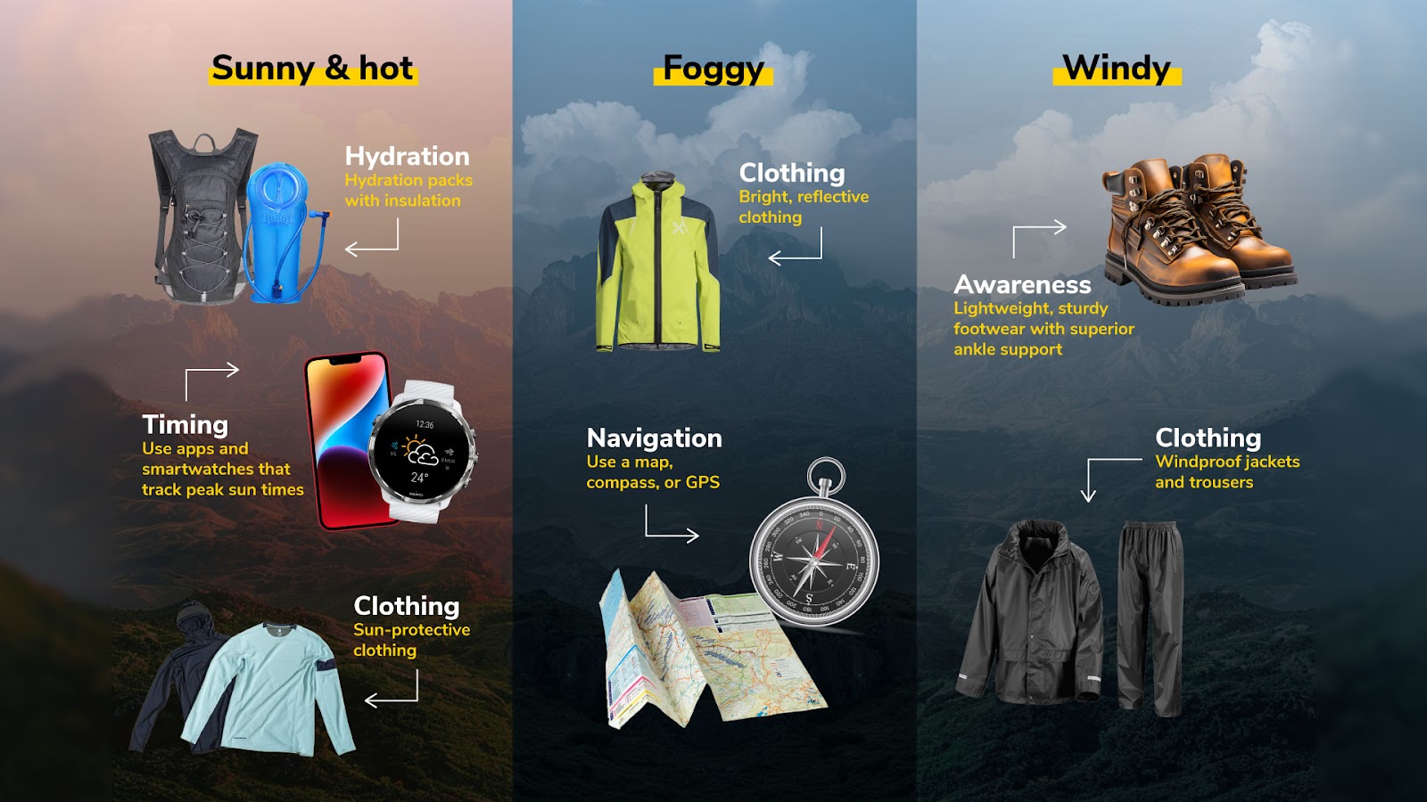
Hydration: Modern hydration packs with insulation can help keep your drinks cool.
Clothing: Sun-protective clothing with moisture-wicking and cooling technologies keeps you comfortable and protected from the sun. Consider lightweight, ventilated hats, too.
Timing: Look into apps and smartwatches that track peak sun times, helping you plan your hikes during cooler hours of the day.
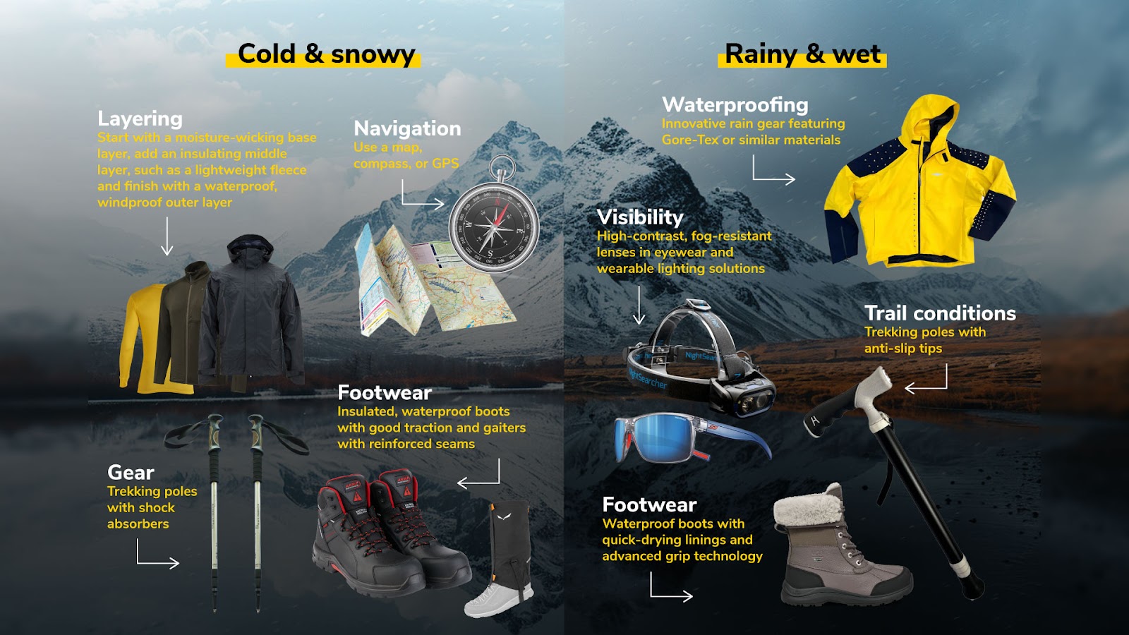
Cold & snowy weather
Layering: Dress in layers. Start with a moisture-wicking base layer made from advanced materials such as polyester or merino wool, which keep you dry by drawing moisture away from the skin. Add an insulating middle layer, such as a lightweight fleece or a high-tech fabric like PrimaLoft, which offers warmth without the bulk. Finish with a waterproof, windproof outer layer. Materials like GORE-TEX are highly waterproof and breathable, with a specialised membrane where water droplets cannot penetrate, but vapour can escape, ensuring you stay dry and comfortable.
Footwear: Wear insulated, waterproof boots with good traction. Consider gaiters with reinforced seams and crampons for deep snow or icy conditions.
Gear: Upgrade your trekking poles to ones with shock absorbers, as this helps your hands avoid injuries that can be caused by uneven terrain and helps to retain balance.
Navigation: Use a map and compass or GPS, as trails may be challenging to follow in the snow. Be aware of avalanche risks in mountainous areas.
Rainy or wet conditions
Waterproofing: Innovative rain gear featuring GORE-TEX or similar materials with enhanced breathability and packability keeps you dry without the bulk.
Footwear: Waterproof boots with quick-drying linings and advanced grip technology reduce the risk of slipping on wet surfaces.
Trail conditions: Trekking poles with anti-slip tips can help navigate slippery paths safely. Unlike traditional metal or carbide tips, which may struggle to provide enough grip on wet and slippery surfaces, anti-slip tips are designed to offer superior grip. This improved traction helps reduce the risk of slipping and provides more stability, making them an excellent choice for wet terrain, especially rock, pavement, cobblestones, or concrete walkways.
Visibility: High-contrast, fog-resistant lenses in eyewear and wearable lighting solutions improve visibility in low-light conditions.
Windy weather
Clothing: Windproof jackets and trousers with built-in ventilation and ergonomic designs help maintain comfort without sacrificing mobility. Buffs can provide added protection against wind and debris.
Awareness: Lightweight, sturdy footwear with superior ankle support helps maintain balance on exposed ridges or narrow paths in windy conditions.
Foggy or misty conditions
Navigation: Use a map, compass, or GPS, as visibility can be severely reduced. Stick to marked trails.
Clothing: Bright, reflective clothing increases visibility to others in foggy conditions.
Innovative gear for different types of terrain
Forest and wooded areas
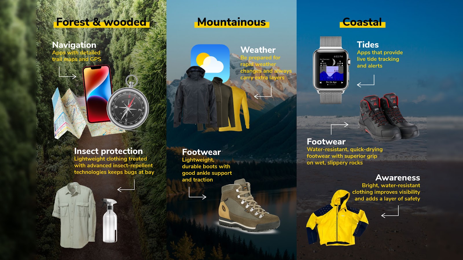
Navigation: Apps with detailed trail maps and GPS ensure you stay on track in dense forests.
Insect protection: Lightweight clothing treated with advanced insect-repellent technologies keeps bugs at bay without needing constant reapplication.
Mountainous terrain
Footwear: Lightweight, durable boots with good ankle support and traction. Trekking poles can be beneficial for steep ascents and descents.
Weather: Be prepared for rapid weather changes. Always carry extra layers, even if the weather is fine at the start.
Coastal trails
Tides: Apps that provide live tide tracking and alerts help plan your route along coastal paths.
Footwear: Water-resistant, quick-drying footwear with superior grip on wet, slippery rocks enhances safety on coastal hikes.
Awareness: Bright, water-resistant clothing improves visibility and adds a layer of safety when navigating near the water's edge.
General tips for enhancing your hiking experience
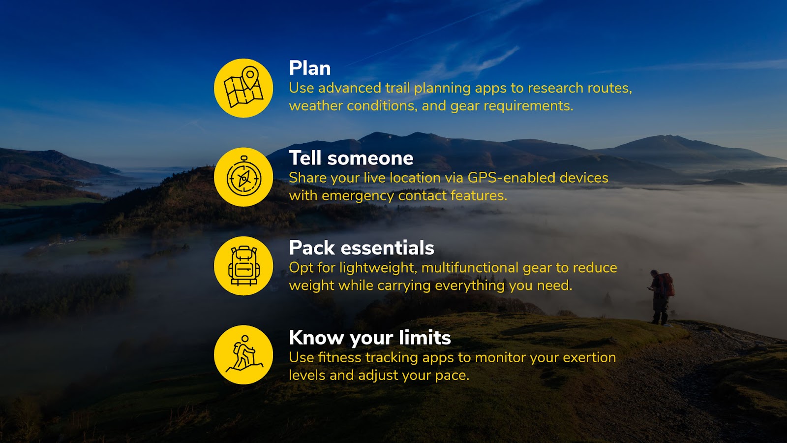
Plan: Use advanced trail planning apps to research routes, weather conditions, and gear requirements.
Tell someone: Share your live location via GPS-enabled devices with emergency contact features.
Pack essentials: Opt for lightweight, multifunctional gear to reduce weight while carrying everything you need.
Know your limits: Use fitness tracking apps to monitor your exertion levels and adjust your pace.
Methodology
We compared the 55 biggest towns and cities in England and the ten biggest in Scotland, Wales and Northern Ireland on the following factors. Each town or city was given a normalised score out of 10 for each factor, and an average of these was calculated. Note that each place is only compared against those from the same country, with the scores calculated relative to these.
The number of outdoor trails sourced using AllTrails per 10km2 using area sourced from City Population.
The average trail review rating out of five was sourced using AllTrails.
The percentage of moderate-difficulty trails sourced using AllTrails.
The percentage of hard-difficulty trails sourced using AllTrails.
The percentage of trails with 1,000m+ elevation gain sourced using AllTrails.
The percentage of 20km+ trails sourced using AllTrails.
The percentage of dog-friendly trails sourced using AllTrails.
The percentage of trails with water views sourced using AllTrails (looking at trails with rivers).
The percentage of trails with wildlife sourced using AllTrails.
The percentage of trails with wildflowers using AllTrails.
The percentage of trails with eateries sourced using AllTrails, looking at pub walks.
Average trail rating sourced using AllTrails.
The number of social media posts for sunsets and sunrises in each city was sourced using Instagram and TikTok, looking at posts using the tags #[City]Sunset, #Sunset[City], #[City]Sunrise, and #Sunrise[City]. These were sourced on July 19, 2024.
The average temperature in °C was sourced using Climate-Data.org. It was calculated by taking the average of each month’s average temperature.
The average annual precipitation in millimetres was sourced using Climate-Data.org.
The number of outdoor activities sourced using Tripadvisor per 10km2.
The percentage of wheelchair-friendly and accessible restaurants sourced using Tripadvisor.
The number of campsites sourced using Campsites.
We also took the number of posts on Instagram and TikTok for each of the following terms:
#[City]Walk
#[City]Walks
#[City]Walking
#Walking[City]
#[City]Hike
#[City]Hikes
#Hiking[City]
#[City]Hiking